

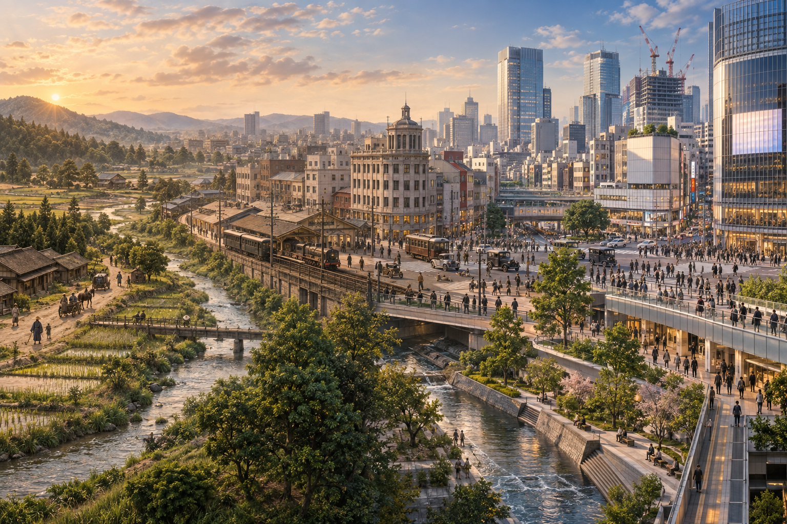
Shibuya is often reduced to a few familiar images: the Scramble Crossing, giant video screens, youth fashion and new towers. Yet the district was shaped by much more than trends. A river valley, a station opened in 1885, suburban railways, department stores, postwar road building and today’s station redevelopment have repeatedly changed how people move through the neighborhood.
This guide follows Shibuya from its early landscape to the modern city and the construction now under way. Knowing that history makes the slopes, split-level station, hidden river and layered pedestrian decks easier to understand.
Contents
- A city formed by valleys and water
- The station and modern Shibuya
- Railways, department stores and culture
- Postwar growth and the hidden river
- What is changing now
- A history-focused walk
Shibuya began with valleys and water
Shibuya City’s planning documents describe the station area as a bowl-shaped landscape between three plateaus, with the Shibuya and Uda rivers running through it and an elevation difference of roughly 20 meters. The terrain is still visible in names and slopes such as Dogenzaka, Miyamasuzaka and Sakuragaoka.
During the Edo period, the area consisted largely of villages and settlements along roads. Water ran along the low ground, while paths connected the plateaus with the valley floor. Shibuya Station was therefore not placed on an empty, level site: railway lines were inserted into a place already constrained by rivers and steep slopes.
1885: the station changes the direction of the town
According to Shibuya City Library’s historical materials, Shibuya Station opened in 1885 on the Nippon Railway’s Shinagawa Line. It was not yet a major terminal, but the railway gradually moved the district’s center of gravity toward the station.
Streetcars and suburban railways followed. The Tokyo Yokohama Electric Railway reached Shibuya in 1927, strengthening its role as a gateway between the city center and growing residential suburbs. Concentrating several lines in the low part of a valley supported Shibuya’s growth, but it also helped create the vertical and often confusing transfer system travelers encounter today.
Railways and department stores create a commercial center
In the early 20th century, railway companies developed stations and shopping together. Department stores turned the terminal from a place to catch a train into a destination for shopping, meals, entertainment and meeting friends. The basic formula—transport bringing people together, then commerce and culture growing around that flow—still defines Shibuya.
The buildings and fashions have changed many times, but the district has repeatedly used its position as a transport hub to introduce new forms of city life.
Postwar expansion and the river beneath the streets
After World War II, roads, rail facilities and commercial buildings expanded rapidly. During infrastructure projects in the late 1950s and 1960s, sections of the Shibuya River were moved or covered. Water still flows beneath the east side of the station, although it is easy to pass above it without noticing.
Cinemas, music venues, fashion stores and department stores helped make Shibuya a center of youth culture. From the 1970s onward, areas such as Koen-dori, Center-gai and Spain-zaka developed distinct identities. Shibuya’s appeal did not depend on one landmark; it came from several cultural pockets connected by slopes and side streets.
Since the 2000s: reconnecting a divided district
Rail lines, major roads, underground passages, the river and large buildings had accumulated around the station, making east–west movement and transfers difficult. Redevelopment since the 2000s has therefore focused not only on towers, but on connecting ground level, underground routes and elevated decks.
Shibuya Hikarie opened in 2012, Shibuya Stream in 2018 and the east tower of Shibuya Scramble Square in 2019. Around Shibuya Stream, a riverside pedestrian area makes the relationship between the waterway and the city visible again.
What is changing now: station, squares and pedestrian routes
The current station-area project includes rail improvements, Shibuya Scramble Square Phase II, and changes to Hachiko Square and the east-side plaza. Its goal is to distribute pedestrian traffic across several levels and create clearer connections between the station and surrounding districts.
| Planned period | Main change | What it may mean for visitors |
|---|---|---|
| Fiscal 2030 | Main pedestrian network and JR east–west passage scheduled for completion | Easier movement across the station and between lines |
| Fiscal 2031 | Shibuya Scramble Square Phase II scheduled for completion | Expanded station and commercial connections |
| Fiscal 2034 | Overall project, including Hachiko Square, scheduled for completion | The station entrances and public squares reach their planned form |
Plans include an elevated pedestrian network linking major facilities between the upper ends of Dogenzaka and Miyamasuzaka. The idea is to reduce the concentration of people at the valley floor and allow access to the city from both street and deck levels.
Renderings show planned future conditions, not today’s view. Gates, exits, passages and bus or taxi stops can move during construction. Use station signs and staff guidance rather than relying only on an old map or screenshot.
What remains as Shibuya changes
Shibuya is not defined only by new towers. Its slopes, memories of the river, Hachiko meeting place, live houses, fashion and small restaurants preserve layers from different periods. Redevelopment is not simply replacing an old town with a new one; it is also an attempt to reconnect railways, public space and the geography that made the district complicated in the first place.
A short walk for reading Shibuya’s history
- Hachiko Square and Scramble Crossing: observe today’s concentrated pedestrian flow and temporary construction routes.
- Dogenzaka or Miyamasuzaka: walk uphill to feel how the station sits in a valley.
- Shibuya Hikarie and the east side: compare ground, underground and deck-level circulation.
- Shibuya Stream and the Shibuya River: see where the waterway becomes visible south of the station.
- Sakuragaoka: compare the redeveloped blocks with the natural slope of the neighborhood.
Allow about one to two hours and leave extra time for detours. The point is not to collect every landmark, but to notice how geography, transport and new construction overlap.
Frequently asked questions
When did Shibuya Station open?
It opened in 1885 on the Nippon Railway’s Shinagawa Line. Later railway arrivals transformed it into a major terminal.
Does the Shibuya River still exist?
Yes. Parts of it run underground near the station, while the river and landscaped waterside can be seen around Shibuya Stream to the south.
When will redevelopment finish?
Current plans target fiscal 2030 for the main pedestrian network, fiscal 2031 for Shibuya Scramble Square Phase II and fiscal 2034 for the overall project including Hachiko Square. Schedules may change.
Official sources
Information checked October 7, 2026: Shibuya Station Area Vision, Shibuya City’s official Shibuya River materials, Shibuya City Library’s railway history guide, the operators’ station district plan announcement, and Tokyu’s Future Shibuya project page.
The featured image is an editorial illustration combining Shibuya’s valley landscape, railway era and current redevelopment. It is not a historical photograph or an official completion rendering.